Mitate-yama Hike
Follow in the footsteps of Mōri Terumoto, the 16th Century daimyo who had a castle stronghold built upon the Otagawa Delta and, thus, kicked off the development of the modern day city of Hiroshima. Mitate-yama is a short, relatively easy hike with very good access, that offers some nice views over the city and out to Miyajima.
Mitate-yama [見立山] stands only 134.9m high, but back in the late 16th Century that was high enough to afford good views over the Otagawa delta and the island outcrops of Gokamura (五ヶ庄), as it was one of three local peaks climbed by Mori Terumoto when he was trying to decide where to locate Hiroshima Castle.
Today, you can just about make out the top of the castle among all of Hiroshima’s large modern buildings, but Mitate-yama does offer some great views across the city and out to Miyajima Island and Aki-no-ko-fuji on the island of Ninoshima. There are better views from nearby Ushita-yama (260.6m), but Mitate-yama is a far less strenuous walk and although not as extensive, things seem much closer from here. You can also catch some nice sunsets here, with the sky and clouds above Miyajima turning red and gold just before the sun dips below the mountains to the west; you can also get down before it gets very dark and are more likely to avoid running into one of the inoshishi wild boar that inhabit these hills.
The Hike
This walk starts from Ushita (Big Wave) Astram Line Station and is only 1.5km (a shade under a mile) each way. Scroll down below the map for a written guide.
View Mitate-yama Hike in a larger map

On exiting Ushita (Big Wave) Astram Line Station (if taking the Astram Line follow signs for Big Wave) make your way into and across the park towards the Big Wave sports center. You’ll find toilets and drink vending machines down the steps to the park in the building below the Astram Station.

Make your way around the sports center to the right and turn left along the main road, keeping on the left. You will soon see a entrance to the left with a road going up a slight slope. Follow the road along the walkway behind the traffic cones to an open space used for parking.

Walk around the outside of the parking area (although you can just hop across the middle) and look for a steep concrete stairway on the right just after you hit the asphalt road you can see heading around a curve up the mountain. Take a breath; you are going to the top of those stairs.

At the top of the stairs, you come out at a European style rose garden (bara-koen). Either take a little break here in the garden (there is also a well kept shelter with a rest space and drink vending machines about 100m to the left), or head straight across and take another (shorter) set of steps. Here, you follow the path to right along the fence which is intertwined with rose bushes.

Follow the path around a couple of bends until you come to some public toilets.
Between 4:30pm and 9am a gate across the path is closed to protect the gardens from wild boar: just go through the silver aluminium gate to the left, not forgetting to close the gate behind you.

Turn left at the toilets and start heading up the asphalt road. To your left you will see the green roof of the city waterworks.
It always looks like a great place for a picnic, but unfortunately it is closed to the public.

The mountain trail entrance is almost immediately after this, on your right. The trail climbs up through dense forest up well maintained steps.
This trail will bring you to a grassy area and you will probably be able to make out a gazebo above you.

Looking ahead you should be able to see another steep set of steps with a route sign at the bottom. The arrow pointing to the right is to Mitate-yama [見立山] and the arrow to the left points to Ushita-yama [牛田山]. Head up the steps and turn right at the top, take another short set of steps and again turn right at the top of those.
Not far now!

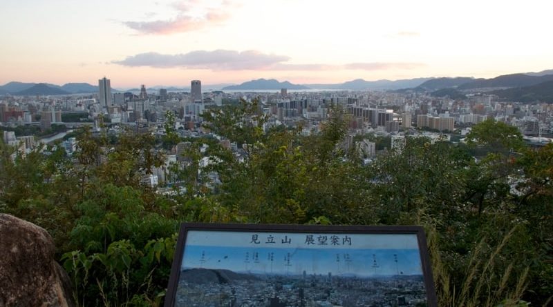
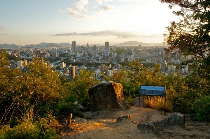
The concrete path passes a shelter on the left and soon changes into a dirt trail. Shoot down a shallow dip and up the other side and you come to a small clearing; this is the top of Mitate-yama (photo at top of post). There is a large sloped rock from on top of which you can get a wonderful view on a clear day, and a panoramic photograph indicating points of interest in Japanese.
Click through the photos below to see some shots of the views you get from the top of Mitate-yama. For more on one of the other mountains used as a vantage point by Mōri Terumoto, Futaba-yama, click here. You can hike all the way to the Peace Pagoda on Futaba-yama via Ushita-yama along a ridge trail we like to call the Ushita Alps (though you’ll have to follow these directions in reverse).